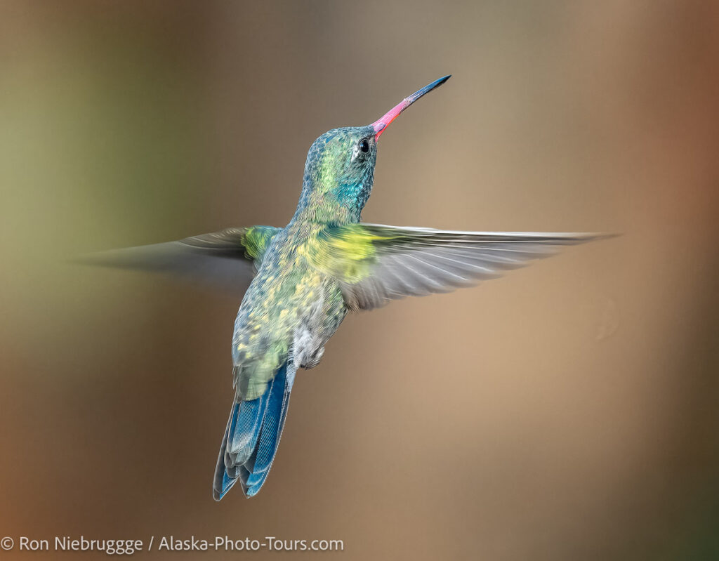
From the category archives:

Arizona

2012 Arizona Calendar

by Ron on October 13, 2011

2012 Arizona Calendar.

2012 Arizona Calendar.

2012 Arizona Calendar.

2012 Arizona Calendar.

This is really cool – Tide-mark published a calendar with 12 of my Arizona photo along with a nice write-up about me – although the photo of me on the inside cover was a risky move that could hurt sales.  :)   I believe these are available through out Arizona, but I see they also sell them on Amazon:

{ 3 comments }

Fountain Hills Phone Book

by Ron on April 26, 2011

Tonto National Forest, Arizona.

Tonto National Forest, Arizona.

Here is another cool cover that came in the mail recently – this photo of Tonto National Forest was used on the cover for the Fountain Hills – Rio Verde – Tonto Verde phone book.

As most of you know, we just spent a couple of weeks just outside of Fountain Hills this winter.  Although this area does sell well for us, I think a big reason we talk ourselves into re-visiting the region is for the amazing mountain biking at the McDowell Regional Park.  If I had to pick just one place to ride – I can’t believe I’m going to say this, but I would pick McDowell even over Moab, Utah.  Well, along with the mountain biking, the mild winter weather helps too.  :)

{ 3 comments }

Salt River

by Ron on April 4, 2011

Salt-River, Tonto National Forest, Arizona.

Salt-River, Tonto National Forest, Arizona.

The Salt River is a popular tubing location during the summer.  Looks fun!  And, I bet much warmer then the Gulkana River in Alaska – a place my friends and I would go tubing on warm summers.

One of the drawbacks with shooting a lot of 3D video on this trip is that I haven’t had as many still photos as I normally would for my blog.   So recently, I have made more of an effort to grab more stills while out shooting 3D – this is one.  For 3D, I like to find scenes like this with many layers to it.  Unfortunately, I won’t know what really if it “works” until I get home – I’m looking forward to processing the video from this trip.

{ 6 comments }

Arizona Wildflower Update – 2011

by Ron on March 25, 2011

Tonto National Forest, Arizona.

Tonto National Forest, Arizona.

What may not show well in this small photo is the nice field of yellow ground wildflowers.

This is definitely been a very poor year for wildflowers, but a stretch of warm weather followed by some a pretty heavy rain last Monday has seemed to produce a mini bloom of wildflowers.

In the two placers I have been spending time, Tonto National Forest, and McDowell Regional Park, I’m beginning to see a few poppies, lupine and brittlebush in bloom.  It isn’t the dramtic colorful hills and fields of wildflowers I have seen in past springs in this area, but at least it is a little something, something.  And, I would think it could get a bit better over the next week or so.

I’ll be making my way to the west side of the state in a few days, it will be interesting to see how that area is doing after the recent rains – I’ll follow up with a report if I find anything worth reporting on!

{ 7 comments }

Saguaro Forest

by Ron on March 24, 2011

Saguaro cactus, Tonto National Forest, Arizona.

Saguaro cactus, Tonto National Forest, Arizona.

With clouds in the sky, and a gap above the horizon to the East – I though sunrise this morning could be epic!  But, it was nothing.  So, I used the nice light to play with these guys instead.

{ 7 comments }

Saguaro Cactus

by Ron on March 23, 2011

Saguaro cactus, Tonto National Forest, Arizona.

Saguaro cactus, Tonto National Forest, Arizona.

This was last night at sunset. I love the unique shapes of these guys – saguaros are cool!

{ 8 comments }

Scottsdale Waterfront Photo

by Ron on March 22, 2011

Scottsdale Waterfront, Scottsdale, Arizona.

Scottsdale Waterfront, Scottsdale, Arizona.

Any water feature seems to really add to a community whether it is a river, lake or ocean.  Towns like Scottsdale and San Antonio, where such things don’t occur naturally have had to get creative in creating a “waterfront”.

This area of Scottsdale has changed a lot since we first visited this region 4 years ago.  Back then, this area was completely under construction.  Last year it was finished, but not much of the landscaping had grown in.  Now, it really is a nice little waterfront with outdoor restaurants, galleries and residential towers.  It is a big change from the sprawling, low density development that has typically taken place in this region.

Downtown Phoenix has changed even more.  Four years ago everything was torn up thanks to the addition of a mass transit rail system, construction of additional convention facilities and office buildings.  Today, all those projects are complete, and it is a nice improvement.

{ 2 comments }

Lesser Goldfinch

by Ron on March 17, 2011

Lesser Goldfinch, Fort McDowell, Arizona.

Lesser Goldfinch, Fort McDowell, Arizona.

I noticed a few people having good luck with bird feeders at this campground so I decided to put one out.  Well, it only took about an hour before goldfinches began to show up!  These colorful birds are a lot of fun to watch and photograph!

{ 9 comments }

Arizona Sunset

by Ron on March 16, 2011

Sunset, McDowell Moutain Regional Park, Arizona.

Sunset, McDowell Mountain Regional Park, Arizona.

We have now moved a bit east into Arizona.  As you can see, there aren’t any wildflowers.  We are here a tad bit earlier then normal, but the lack of wildflowers has much more to do with a dry and unseasonably cold winter that included some freezes.   In some parts of McDowell, many plants appeared dead, hopefully they are just damaged by the freeze.

It is possible that late rains, and now unseasonably warm weather might give us a few flowers – but we definitely won’t be seeing the hills of solid color like we did in 2008.

{ 8 comments }

On The Road Again

by Ron on February 4, 2011

Sonran Desert wildflowers, near Fountain Hills, Arizona.

Sonoran Desert wildflowers, near Fountain Hills, Arizona.

You may have noticed the photo blog activity has slowed down a bit, partly because this rainy, snow-less winter has had me concentrating on office work, and has not provided me with new material for the blog.  But, mostly because we have been trying to get everything wrapped up before our next trip which we leave for on Monday!

Where are we going?  At first we fly to Palm Springs and then head down to Anza-Borrego where we will stay for about a month, and where I will do my Anza-Borrego photo workshop.

After that, believe it or not, we haven’t decided.  With all the rain the Southwest has received, there is a good chance we will chase some wildflowers possibly to Arizona.  But, we have kicked around a few other ideas and may go a different direction.  For now, we have not booked a flight home – we will pick our departure city and date later which makes it kind of fun.

{ 10 comments }

Tucson Photos

by Ron on July 23, 2010

Sabino Canon, Tucson, Arizona.

Sabino Canon, Tucson, Arizona.

Tucson is another of our newly updated sections from this winter.  Our time in Tucson turned out to be a bit brief, but fun, thanks in part to discovering Sabino Canyon.  So check out some new Tucson photos!

{ 6 comments }

Phoenix Photos

by Ron on July 8, 2010

Bartlett Lake, near Phoenix, Arizona.

Bartlett Lake at sunset, near Phoenix, Arizona.

Sticking with the new update theme – Janine now has our website updated with new photos of Phoenix Arizona.  Many of these were captured during our spring trip to the area.

{ 3 comments }

Bartlett Lake, Arizona

by Ron on June 1, 2010

Bartlett Lake, Arizona.

Bartlett Lake, Arizona.

A recently adjusted photo from our spring trip of the wildflowers around Bartlett Lake, Arizona.

{ 8 comments }

Hiking in the Dark

by Ron on May 5, 2010

Sabino Canyon, near Tucson, Arizona and about an 45 minutes before a dark hike down this same hillside.

Sabino Canyon, near Tucson, Arizona and about 45 minutes before a dark hike down this same hillside.

Ron Richins asked this great question recently:

I just saw your last post about SabinoCanyon.  I also saw your post awhile ago about Tower Arch.  The one thing they have in common is that you hiked out in the dark from each location.  Do you have a lot of experience doing this, and does it get easier the more you do it?  I’ve only done a few hikes after dark, and they can be quite unnerving.  I wonder if you could share some tips about hiking prudently after dark.  A headlamp’s a must, but beyond that, what else do you do?  Do you follow tracks left by a GPS?  Or, am I just letting fear rule me more than reason?  This might make for an interesting blog post.

Actually, I don’t do too much hiking in the dark especially in Alaska.  Last summer I actually spent one night only a mile from my home in a tent rather then hike through a pitch dark bear infested forest. :)   There are enough bears around here already – but at night, it seems like every dark stump turns into a bear!

It was in Colorado and Rocky Mountain National Park that I really began doing dark hikes.  There, spending the night wasn’t an option because of restrictions, permits etc., so long hikes in the dark was the only way to be at many locations for sunrise or sunset.  It was easy down there thanks to well marked, well worn trails.  It worked out so well, that I began doing it in other areas -  places like Moab and Tucson like you observed.

So here are some observations:

-  Be extra observant for visual clues, junctions etc.  Even familiar trails look very different in the dark.  It much, much  easier to get lost or miss a trail in the darkness.  Reliable visual references such as mountains and other land features are often impossible to see in the dark.

-  Dark hiking is slow.  Even though it seems like I’m hiking really fast, I’m not!  Allow extra time even on a trail you are familiar – like 25% extra time.

-  A headlamp is a must.  Unlike a flashlight, a headlamp keeps both hands free, and always places the beam of light exactly where you are looking – which is where you want it!

-  I use an old Petzl.  During my last visit to REI I was really tempted to purchase this much brighter version:
Petzl Tactkka Plus LED headlamp
The thing I really like about the Tactikka Plus is the red filter which allows you to maintain your night vision.  I think that feature would be wonderful for night photography – star trails and northern lights.  Keeping your night vision while still having enough light to set up the camera would be a huge benefit.

-  Be sure your headlamps batteries are charged or fresh.

-  I carry a small can of bear spray.  I don’t remember where I bought this small can of spray – I think it might have been at a Bass Pro Shop.  I wouldn’t want such a small can in Alaska, but in the Southwest where I’m more concerned about mountain lions and people, I think it is a great size.

-  I make sure I know where I’m going.  I carefully look over maps and have a good feel for distances between junctions, directions etc.  I haven’t used my GPS on a night hike, but it probably isn’t a bad idea.  It would have been nice for our hike out from Tower Arch in Arches because the distance between cairns was greater then our light beam.  Fortunately on that hike I wasn’t alone.  I had Janine stop at the last cairn with her lamp, while I hiked out until I could find the next pile of rocks, then she could hike back toward my light and we repeated.  It was slow, but safe – especially given the steepness of the final hill.  A GPS cookie trail would have come in handy.

-  Go with a friend.  Not only is it safer like in the situation above, but it also makes it more fun and less spooky.  If I’m talking with someone then my mind is less likely to turn every stump into a monster like my mind does when I’m alone!

-  Be extra prepared.  I usually bring an extra shell or jacket, trail bars and water just in case I have to wait until morning to find my way.

I know what you are saying about how unnerving it can be when hiking in the dark – it is for me as well.  But, it does seem to get easier the more I do it.  I don’t think I will ever get to the level of comfort as I found in a young couple from South Africa.  I was camped late one summer night on the edge of the Harding Icefield in Alaska.  At 1:00 a.m in the total darkness they showed up without even a flashlight.  There are so many bears on that trail during the day, I can’t imagine making that long hike in the dark.  When I asked them about it the next day they just shrugged it off like it was nothing.

{ 9 comments }

Photo Rescue to the Rescue!

by Ron on April 21, 2010

McCormick Ranch Golf Course, Scottsdale, Arizona.

McCormick Ranch Golf Course, Scottsdale, Arizona.

Here is a mistake I have never made before – I went out one evening to photograph sunset in the hills above Scottsdale, and noticed my card was nearly full.  I did a quick look – perfect, these have been downloaded and backed up, so I formatted my card and began shooting.  It wasn’t until I got back to camp that I remembered that I had photographed Scottsdale and the McCormick Ranch the night before and hadn’t backed up or downloaded those images – I just wiped out that evenings work!

I couldn’t believe it – I’m always so careful.  I told Janine that if we ever get any requests for photos of McCormick Ranch, don’t tell me!  I didn’t lose anything that was going to win awards or solve world peace, but it is still a bummer to lose a nights work.

So I decided to see if I could rescue the images – even though the card was formatted, as long as the new images weren’t written over the old, I thought there might be a chance, and I had nothing to lose.  I downloaded a recovery program, and didn’t have any luck.  I then thought of Photo Rescue.  I noticed that I could download a free version that would search your card and tell what it found before you actually had to buy the program – so I would know if it could work before parting with the cash.  Well, sure enough, I believe it found every photo from that night!  I couldn’t believe it, and happily paid the $29 for the actual program.  It successfully recovered every image.

The ironic thing is that this same SanDisk Extreme card came with Photo Rescue on it for free, so I’m sure I had a copy at home – this is just another reason to use  SanDisk Extreme cards.  In the future I will make sure I have that program on my laptop when I travel.

So if you ever unintentionally delete, format, or just have a card go bad, don’t give up until you try Photo Rescue!

{ 17 comments }

Mission San Xavier delo Bac

by Ron on April 9, 2010

Mission San Xavier delo Bac

Sunrise on Mission San Xavier delo Bac, Tucson, Arizona.

This beautiful mission is over 300 years old!

{ 8 comments }

Sabino Canyon

by Ron on April 8, 2010

Sabino Canyon, Tucson, Arizona.

Sabino Canyon, Coronado National Forest, Tucson, Arizona.

This is looking down into Sabino Canyon a little after sunset.  I had never been here before and have I missed out – it is beautiful!  A nice stream flows down the middle of the canyon, and access is provided by an open air shuttle system, although you can always walk, or after hours,  bike into the canyon.  And speaking of walking, there are lots of great hiking trials.  It is a very poplar area, I was surprised that even during my hike out in total  darkness that I ran into a number of hikers and joggers.

{ 5 comments }

Black Hills

by Ron on April 7, 2010

Black Hills, Arizona.

Black Hills, Arizona.

Here is another from the Black Hills, Arizona.

Photographing poppies is a bit of a trade-off because they tend to closed around sunrise and sunset.  So the better the light, the less of a wildflower show.  As you can see here in the photo at last light – many of the wildflowers are nearly closed.  Fortunately these fields are so dramatic that they still look great!

{ 8 comments }

Black Hills, Arizona

by Ron on April 6, 2010

Black Hills, Arizona.

Black Hills, Arizona.

The Black Hills of Arizona are not so black right now!  This is between Safford and Clifton near the New Mexico border.  I think this area rivals even the famous Antelope Poppy Reserve in California, it is dramatic.  This was Sunday evening – unfortunately this area was hit with 40 mph winds on Monday which probably put a big damper on the current show.

{ 10 comments }

McDowell Sonoran Preserve

by Ron on April 5, 2010

McDowell Sonoran Preserve, Scottsdale, Arizona.

McDowell Sonoran Preserve, Scottsdale, Arizona.

The Brittlebush is finally coming into bloom!  The mountains are sure green for the desert, hard to believe this is a desert.

The residents of Scottsdale have voted a number of times to increase their sales tax rate in order to raise money for the purchase of  private land in the mountains near town, thus forming the McDowell Sonoran Preserve.  It is a wonderful Preserve – beautiful scenery and wonderful trails.  When we weren’t mountain biking for exercise, we would come to this area for a trail run.  Thanks Scottsdale!

We are moving on for a brief visit to Tucson before heading back to Alaska.  It was a bit tough leaving Fort McDowell.  We had the best campsite tucked way off in the corner with no one around.  We over looked the Verde River and could see an active bald eagle nest – it was a great, quiet little location.  We received nearly daily visits from a road runner pair, some baby rabbits, flickers and a wide variety of birds.  We even had a brief visit from javalina.

{ 6 comments }

Downtown Phoenix

by Ron on April 2, 2010

The light rail Valley Metro and Phoenix Convention Center North, Downtown Phoenix, Arizona

The light rail Valley Metro and Phoenix Convention Center North, Downtown Phoenix, Arizona

This photo epitomizes one of the reason we returned to Phoenix.  Two years ago, the downtown streets were completely torn up due to the construction of the Valley Metro light rail project, and this block was giant construction project as they were hard at work on this brand new convention center.  The downtown area is much nicer now that these big projects are completed.

As a side note, I found it difficult to capture a photo of the Valley Metro without an accompanying automobile even on the weekend.  It didn’t take me long to realize that the train appeared to control the signals at all but a couple of the busiest intersections, and I’m sure it didn’t take drivers long to figure that out either.  So a car that mirrored the speed of the train could be assured of hitting most signals during a green light.  The few lights it didn’t seem to control were major arteries running perpendicular to the rail and I assumed must be timed signals for traffic flow.  How is that for more then you ever wanted to know about downtown Phoenix traffic!

{ 7 comments }

To share or not to share

by Ron on April 1, 2010

Flowers along Highway 60 near Superior, Arizona.

Flowers along Highway 60 near Superior, Arizona.

I have linked here to Carol Leigh California Wildflower Hotsheet a number of times over the years and have always found the hot-sheet and her forum to be an extremely valuable resource.  Yesterday it was brought to my attention that Carol stopped maintaining the hot sheet, a decision that may become permanent.   She writes:

Right now I cannot in good conscience continue to distribute “where-to-go” wildflower information. Private property is being destroyed. Flowers are being trampled. Rude and inconsiderate behavior abounds.

I don’t know Carol, but it is clear she has a real love and passion for wildflowers.  Although I will miss her updates, I respect her decision to put the wildflowers first.  But it does raise a larger question;  how much should we share, and as photographers, are we helping to destroy  special places by publicizing them?

I have had this discussion with many photographers over the years, and have some photographer friends who keep everything close to the proverbial  (photo) vest, and others who share most anything.  I personally tend to share far more then most, and I think it is a big reason why my photo blog has become popular.  Not just locations, but techniques and most anything I know.  There are topics in which I have drawn a distinct line, the main one that comes to mind is the location of winter animal sightings for animals like lynx – because I know a trappers love of animals directly competes with my own.

But in recent years I have decided to keep some physical locations private.  This amazing spot in Valley of the Fire is one that immediately comes to mind.  I would like to say I have some noble motivation to keep the location secret to help protect it, but frankly, often motivation is largely selfish.  I like the idea of having an amazing location all to myself.  To have a spot like that crawling with people, muting the colors with their footsteps would “ruin” it a bit for me, and could ruin it for generations to come.

But there is more to my motivation.  I like to think of myself as a photographer, and tend to avoid the label businessman, but truth be told I am in business and this is our sole source of income, and frankly the fewer people who have photographs of an area I have found,  the better it is for me.  Certainly Ford would never share a discovery with Chevy, and no one would expect them to, but the same expectation isn’t always applied to photographers.  I have been surprised at the questions other photographers have asked me over the years, and disappointed in how few take the time to email a quick “thanks” in response – more often then not I end up asking myself why did I just share that information?

I know there isn’t a right or wrong answer, and my opinion will likely continue to ebb and flow over the years, but I’m interested in how much others are willing to share and why?

{ 46 comments }

Bartlett Lake Photos

by Ron on March 30, 2010

Bartlett Lake, Tonto National Forest near Phoenix, Arizona.

Bartlett Lake, Tonto National Forest near Phoenix, Arizona.

Bartlett Lake has some of the best wildflowers of any place we have visited so far this spring.

{ 15 comments }

Arizona Spring

by Ron on March 29, 2010

Tonto Natoinal Forest, Arizona.

Tonto National Forest, Arizona.

This was a cloudy evening late last week – I thought chances were good for a sunset, but it didn’t happen.   I intend to explore this area some more this week – I love the rocks!

{ 4 comments }

Apache Trail

by Ron on March 26, 2010

Mountains along the Apache Trail, East of Phoenix, Arizona.

Mountains along the Apache Trail, East of Phoenix, Arizona.

Yesterday, photo blog reader Joni reiterated a prior recommendation for the Apache Trail – I figured I better heed her advice, so we drove out that way yesterday evening.  I wasn’t disappointed!  It is a beautiful area.  I’m looking forward to returning and driving a bit further, we didn’t make it too far past Tortilla Flat.  There are a few places with nice flowers, and lots of places that are very green!  I think the wildflowers should start looking nice in about a week.

Related Posts Plugin for WordPress, Blogger...

{ 8 comments }